Earthquakes
Worldwide, straight from the USGS feed. Rings scale with magnitude, so a swarm reads at a glance. Tap one for magnitude, depth, time and place.
Every earthquake USGS reports, sized and coloured by magnitude. Every wildfire, flood, volcano and storm NASA is tracking. All of it on the same globe as the aircraft, satellites and cameras, so you can see what's going on around any place on Earth.
Free · iPhone, iPad and Apple Silicon Macs · no account, no tracking
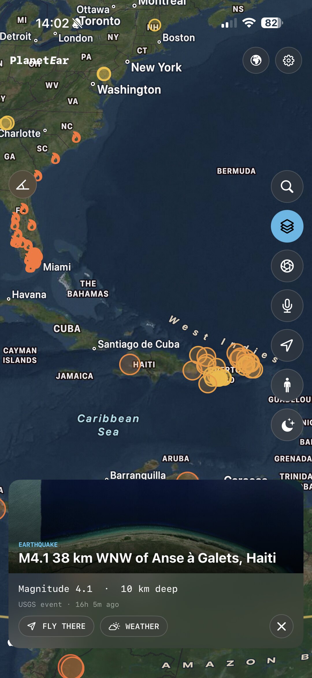
Each event is a tappable pin with the source's own details: magnitude and depth for a quake, the dates and name for a fire or flood, and a link back to the agency that reported it.
Worldwide, straight from the USGS feed. Rings scale with magnitude, so a swarm reads at a glance. Tap one for magnitude, depth, time and place.
Active fires curated by NASA's Earth Observatory Natural Event Tracker (EONET), with the date they were first reported and how long they've been burning.
Major floods, tropical cyclones and severe storms from the same NASA feed, placed where they're happening and updated as the event moves.
Eruptions and significant sea and lake ice events, for the parts of the planet that change on their own schedule.
Planning a trip? Enter a destination and get the UK Foreign Office's advice as scannable region cards, plus official GDACS disaster alerts near where you're going.
Tap or ask for the conditions and forecast at any point on the globe, and check space weather from NOAA for aurora and solar activity.
PlanetEar shows what the agencies publish and credits them on every pin. It never makes up a danger rating of its own.
| What | Source | Notes |
|---|---|---|
| Earthquakes | USGS | United States Geological Survey real-time earthquake feed, worldwide. |
| Wildfires, floods, volcanoes, storms, ice | NASA EONET | Earth Observatory Natural Event Tracker: open events curated from authoritative sources. |
| Disaster alerts (Travel Intelligence) | GDACS | Global Disaster Alert and Coordination System, run by the UN and the European Commission. |
| Travel advice (Travel Intelligence) | UK FCDO | Foreign, Commonwealth & Development Office advice, Open Government Licence v3.0. |
| Weather | Open-Meteo | Conditions and forecast for any location. |
| Space weather | NOAA SWPC | Solar activity and geomagnetic conditions. |
PlanetEar is for awareness, not warnings. It shows events after the agencies publish them and has no alerting of its own. For evacuation orders and safety instructions, always follow your local civil authority.
As soon as USGS publishes them to its real-time feed, which is usually within minutes of the event. PlanetEar refreshes the layer while it's switched on.
No. It shows events that have already been reported, so you can see what's happening around a place. It does not send alerts and it is not a substitute for official warnings from your local authorities.
Earthquake rings scale with magnitude and are coloured from minor to major. Travel Intelligence region cards are red, amber or green exactly as the Foreign Office rates them, and disaster alerts fade with distance from your destination. Nothing is scored by PlanetEar itself.
Yes. USGS reports earthquakes worldwide and NASA EONET tracks events on every continent. Travel advice comes from the UK Foreign Office, which covers every country.
No. Everything on this page works the moment you open the app, with no sign-up, no key and no payment.
Yes. PlanetEar runs on iPhone, iPad and any Mac with an M1 chip or later.
Earthquakes, fires, floods and storms on a living globe. Free on the App Store for iPhone, iPad and Mac.